|
|
|
 |
|
| Wednesday 31 |
16.81
mi |
27.05
km |
|
|
|
|
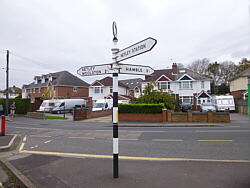
| Home to Lower Swanwick |
7.35
mi |
11.83
km |
|
| Over Cobden Bridge and through
Riverside Park to Mansbridge.
From there along the A27 to Swanwick
Shore Road. Quite hilly along
the A27, this used to be my main
route. |
|
| Lower Swanwick to Warsash
|
4.82
mi |
7.76
km |
|
| Followed the river path to Warsash
beach, passing the Hamble ferry
and the Rising Sun pub. Then through
the nature reserve, up to Warsash
village and down to the ferry. |
|
| Hamble Quay to Netley
Station |
4.64
mi |
7.47
km |
|
| Up Green Lane and through Hamble
Common to Hamble Point. Along
Hamble Shore, through the Royal
Victoria Country Park and out
to Hound Road, Hamble Lane and
Hamble station. With the train
delayed, went along the Rail Trail
footpath and The Badgers to Netley
station. |
| |
| Photo: The
river Hamble at Lower Swanwick.
31.05.17 |
|
|
|
|
|
 |
|
| Friday 26 |
12.46
mi |
20.05
km |
|
|
|
|
| Home to Hamble Quay |
7.91
mi |
12.73
km |
|
| Via the Itchen Boardwalk, under
Northam Bridge, Chapel, over the
Itchen Bridge, through Woolston
to Weston Shore, Netley and the
Royal Victoria Country Park and
down Hamble Lane to Hamble village
then Hamble Quay. |
|
| Hamble Quay to Netley
Station |
4.55
mi |
7.32
km |
|
| Up Green Lane and through Hamble
Common to Hamble Point. Along
Hamble Shore, through the Royal
Victoria Country Park and out
to Hound Road. From there along
the Rail Trail footpath to Hamble
Station. |
|
| With the train home delayed
by a few minutes, I just had enough
time to get to Netley station
via Hamble Lane, Hound Road and
The Badgers. |
| |
| Photo: Hamble
Quay. 26.05.17 |
|
|
|
|
|
 |
|
| Thursday 25 |
10.40 mi |
16.74 km |
|
|
|
|
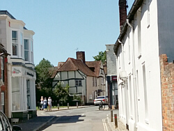
| Swanwick Station to Titchfield |
2.79 mi |
4.49 km |
|
| Via Park Gate shopping centre,
Southampton Road retail park and
Southampton Hill. |
|
| Titchfield to Warsash
Ferry |
3.80 mi |
6.12 km |
|
| Coach Hill, Common Lane, Warsash
Road, Shore Road, Warsash Shore,
Footpath. |
|
| Hamble Quay to Hamble
Station |
3.81
mi |
6.13
km |
|
| Up to Hamble Square, along School
Lane to Hamble Point. Along Hamble
Shore, through the Royal Victoria
Country Park and out to Hound
Road. From there along the Rail
Trail footpath to Hamble Station. |
| |
| Photo: Titchfield.
25.05.17 |
|
|
|
|
|
 |
|
| Wednesday 24 |
11.57
mi |
18.62
km |
|
|
|
|
| Home to Hamble Square |
7.72
mi |
12.42
km |
|
| Via the Itchen Boardwalk, under
Northam Bridge, Chapel, over the
Itchen Bridge, through Woolston
to Weston Shore, Netley and the
Royal Victoria Country Park and
down Hamble Lane to Hamble village. |
|
| Hamble Square to Hamble
Station |
3.85
mi |
6.20
km |
|
| Up Green Lane and through Hamble
Common to Hamble Point. Along
Hamble Shore, through the Royal
Victoria Country Park and out
to Hound Road. From there along
the Rail Trail footpath to Hamble
Station. |
|
|
|
| |
| |
| Photo: Hamble
Quay. 24.05.17 |
|
|
|
|
|
 |
|
| Tuesday 16 |
8.77
mi |
14.11
km |
|
|
|
|
| Bursledon Station to Warsash
Ferry |
3.75
mi |
6.04
km |
|
| From the station to the main
road and over the river. Via Shore
Road and the river Hamble footpath
to Warsash. Up to the village,
across Strawberry Field and back
to the ferry. |
|
| Hamble Quay to Netley
Station |
5.02
mi |
8.08
km |
|
| Up Green Lane and through Hamble
Common to Hamble Point. Along
Hamble Shore, through the Royal
Victoria Country Park and out
to Hound Road. From there to Hamble
Lane and Hamble Station, then
along the footpaths to Netley
station. |
|
|
|
| |
| |
| Photo: The
river Hamble footpath. 16.05.17 |
|
|
|
|
|
 |
|
| Friday 12 |
12.83
mi |
20.65
km |
|
|
|
|
| Home to Hamble Square |
7.72
mi |
12.42
km |
|
| Via the Itchen Boardwalk, under
Northam Bridge, Chapel, over the
Itchen Bridge, through Woolston
to Weston Shore, Netley and the
Royal Victoria Country Park and
down Hamble Lane to Hamble village. |
|
| Hamble Square to Royal
Victoria Country Park |
2.97
mi |
4.78
km |
|
| Down to Hamble Quay, back up
to Hamble Square, down to Hamble
Point and along the shore to the
country park cafe for a break. |
|
| Royal Victoria Country
Park to Netley Station |
2.14
mi |
3.44
km |
|
| Out to Hound Road, then Hamble
Lane, Hamble station, the footpath
to the country park, across the
end of the park to Hound Road
and along the footpath and The
Badgers to Netley station. |
| |
| Photo: Hamble
Quay at the Beach Hut cafe. 12.05.17 |
|
|
|
|
|
 |
|
| Wednesday 10 |
12.61
mi |
20.29
km |
|
|
|
|
| Home to Hamble Square |
7.74
mi |
12.46
km |
|
| Via the Itchen Boardwalk, under
Northam Bridge, Chapel, over the
Itchen Bridge, through Woolston
to Weston Shore, Netley and the
Royal Victoria Country Park and
down Hamble Lane to Hamble village. |
|
| Hamble Square to Royal
Victoria Country Park |
2.72
mi |
4.38
km |
|
| Down to Hamble Quay, up the
hill (Green Lane) and through
Hamble Common to Hamble Point,
then along the shore to the country
park. |
|
| Royal Victoria Country
Park to Netley Station |
2.15
mi |
3.46
km |
|
| Out to Hound Road, then Hamble
Lane, Hamble station, the footpath
to the country park, across the
end of the park to Hound Road
and along the footpath and The
Badgers to Netley station. |
| |
| Photo: Hamble
Quay. 10.05.17 |
|
|
|
|
|
 |
|
| Saturday 6 |
15.21
mi |
24.48
km |
|
|
|
|
| Home to Warsash Village |
9.51
mi |
15.30
km |
|
| Via the Itchen Boardwalk, under
Northam Bridge, Chapel, over the
Itchen Bridge, up Portsmouth Road,
through Old Netley, Lowford and
Sarisbury Green. |
|
| Warsash Village to Ferry |
0.76
mi |
1.22
km |
|
| Via Strawberry Field to the
waterfront and along the footpath
from Passage Lane to the ferry. |
|
| Hamble Quay to Royal Victoria
Country Park |
2.79
mi |
4.49
km |
|
| Visited the Spring Fair at Hamble
Quay then up to Hamble Square,
down to Hamble Point and along
the shore to the country park
cafe for another break. |
|
| Royal Victoria Country
Park to Netley Station |
2.15
mi |
3.46
km |
|
| Out to Hound Road, then Hamble
Lane, Hamble station, the footpath
to the country park, across the
end of the park to Hound Road
and along the footpath and The
Badgers to Netley station. |
| |
| Photo: Strawberry
Field, Warsash. 06.05.17 |
|
|
|
|
|
 |
|
| Thursday 4 |
20.68
mi |
33.28
km |
|
|
|
|
| Home to Hamble Quay |
15.70
mi |
25.27
km |
|
| Via Portswood Road, Woodmill
Lane, Wessex Lane and Wide Lane
to Eastleigh. Then Bishopstoke,
Fair Oak, Horton Heath, Hedge
End village centre, St John's
Road, the A27 and Hamble Lane
to Hamble Square and Hamble Quay. |
|
| Hamble Quay to Royal Victoria
Country Park |
2.80
mi |
4.51
km |
|
| After a short break at Hamble
Quay, back up to Hamble Square,
down to Hamble Point and along
the shore to the country park
cafe for a longer break. |
|
| Royal Victoria Country
Park to Netley Station |
2.18
mi |
3.51
km |
|
| Out to Hound Road, then Hamble
Lane, Hamble station, the footpath
to the country park, across the
end of the park to Hound Road
and along the footpath to Netley
station. |
| |
| Photo: Fair
Oak Square. 04.05.17 |
|
|
|
|
|
 |
|
| Tuesday 2 |
15.16 mi
|
24.40
km |
|
|
|
|
| Home to Hamble Square |
7.77
mi |
12.50
km |
|
| Via the Itchen Boardwalk, under
Northam Bridge, Chapel, over the
Itchen Bridge, through Woolston
to Weston Shore, Netley and the
Royal Victoria Country Park and
down Hamble Lane to Hamble village. |
|
| Hamble Square to Royal
Victoria Country Park |
2.91
mi |
4.68
km |
|
| After a break at Hamble Quay,
back up to Hamble Square, down
to Hamble Point and along the
shore to the country park cafe
for another break. |
|
| Royal Victoria Country
Park to Netley Station |
4.48
mi |
7.21
km |
|
| Out to Netley village, up Station
Road and along Hound Way to Hound
Road. Down the old part of Hound
Road and back through the country
park to Hamble Lane. From there
to Hamble station and then Netley
station via the rail trail footpath,
the country park, Hound Road,
the footpath and The Badgers. |
|
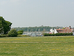
| Photo: The
shore at the Royal Victoria Country
Park. 02.05.17 |
|
|
|
|
|
| More information and links |
|
|
|